
4-Eye Camera: A Method to Enhance Photographs by Transferring Texture and Contrast from NIR Images (09129N)
A method to enhance color photographs using only two images: a near infrared photograph and a color photograph. The method can be implemented directly in hardware or software. Read More |

GeoVid: Capture and Management of Sensor-Enhanced Video (11119N)
The GeoVid system tags video with sensor properties (meta-data) during recording. Collected and correlated meta-data are then utilised for storing, indexing, searching, handling and presenting large collections of videos in novel and useful ways. Videos with meta-data can be better managed, searched and presented. Read More |
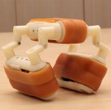
Catapy - Toy Car Which is Covered by a Caterpillar Track (11270N)
A palm-size battery-powered toy car covered by a caterpillar track that is able to run freely in and off-road in regular and irregular surfaces. Catapy can overcome obstacles by automatically changing directions after colliding and bouncing off them. Catapy can be combined to create more exciting configurations that retain the properties of its individual components. Read More |
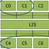
Bahurupi: A Polymorphic Heterogeneous Multi-Core Architecture (11357N)
A polymorphic heterogenous multi-core architecture that can be tailored at runtime under software directives. Bahurupi successfully re-conciliates the conflicting requirements of applications with explicit thread-level parallelism (TLP) and single-threaded serial applications with high degree of instruction-level parallelism (ILP). Read More |

A Beam-Search Decoder for Grammatical Error Correction (12155N)
This is a method for automatic correction of grammatical errors made in written text. It has the ability to correct complete sentences that may contain multiple and interacting errors. Read More |

AirSignature: Authentication on Smart Devices Using Body Movements (13239N)
AirSignature is a motion recognition application that can detect and track a user's unique motion pattern. The AirSignature thus created can be saved and used to authenticate users into their devices or systems. Read More |
Raw2Raw: A Format for Manipulation of Raw Images (14143A)
This invention consists of a method to estimate a mapping (transformation) that can convert a raw image of an arbitrary scene and illumination from one camera’s raw space to another. Read More |
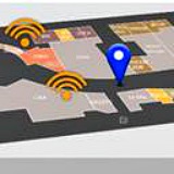
PlaceMap: Automatic Indoor Map Construction Using User Movements (14159N)
This invention is a localisation system that utilises sensed data contributed by users to automatically build indoor maps. Read More |
Lumigrafy: Method for Creation of Enhanced Images by Compositing Multiple-Illumination Photo-Sets (14257N)
Lumigrafy creates bold, enhanced images from multiple illumination photos of a static scene. The technique composites parts of illuminations such as key lights, back-lights and grazing illumination to automatically create beautiful images. Read More |
A Power-Gap Elimination and Unsupervised Training (PEUT) Algorithm For Indoor Localisation (15208N)
A low cost localisation solution for mobile devices in indoor environments based on two algorithms (PE - power-gap elimination and UT - unsupervised training) to eliminate training costs using historical RSS records on mobile phones and to deal with mobile phone diversity. Read More |
A Heat-Deforming Method for Thermoplastic Materials Using Microwave Susceptors (15165N)
A method to deform thermoplastic materials using a microwave susceptor that allows folding of the material to produce interesting configurations. Read More |
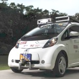
SMART Driverless Vehicle Software (14415S-FM)
This invention enables suitably equipped automobiles to drive themselves from an origin to a destination point on a known road network while avoiding collisions with obstacles, pedestrians, or other vehicles. Read More |
Aspect-Based Sentiment Analysis Engine (14375N)
An aspect-based sentiment analysis engine to perform fine-grained sentiment analysis on text-based content. Read More |

Trusted Data Service (14370N)
A Java library to perform secure big-data analytics. It provides a trade-off in security and performance when doing big-data analytics on untrusted clouds. Read More |
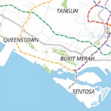
GeoVast: A Geospatial-Temporal Analytical Software (13347N)
GeoVast allows interactive exploration of spatial-temporal incidences and disease trends in Singapore. It runs on a stand-alone server and the visualisation is based on Google Maps or similar API with the capability to display results via an easily comprehended and intuitive interface. Read More |
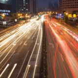
Distributed Traffic Signal Control for Maximum Network Throughput (11396S-FM)
A traffic signal control system based on backpressure routing with distributed application, minimal tuning and support for large traffic networks. Read More |
